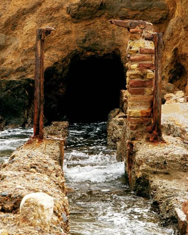
Salt farming went on from the Roman era until the 20th century The entrance to the old salt farm channel Did you know that there used to be a large salt farm in the Port of Mazarrón during the 20th century? This activity, which probably dates back to the Roman era, took advantage of the area’s unique geography to extract sea salt using evaporation of seawater in shallow tanks. The cycle was seasonal: in spring the dykes and walls..
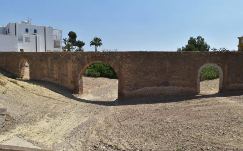
The structure was in use until the late 20th century to supply water to farmsteads in El Alamillo Alongside the RM-332 as it skirts the north of Puerto de Mazarrón and just next to the El Alamillo is the Acueducto del Arco, a1 18th- or 19th century aqueduct built of rock, mortar and occasional brickwork on the inside of the arches which allow floodwater to flow underneath in times of heavy rain. This structure was used to supply fresh water..
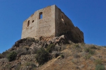
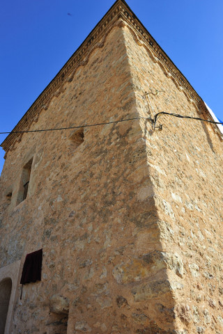
The Castle of Los Vélez in the town of Mazarrón This 15th century fortress is in the heart of the town of Mazarrón, on a small hill about 30 metres above the surrounding ground. This placed it right at the centre of what is now the old part of the town, and the original choice of location was doubtless made with a view to keeping watch over both the population and the mining activity in the surrounding area. The castle was built towards..
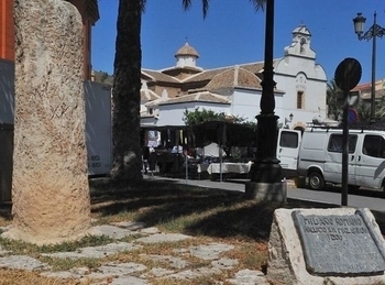
Milario romano Mazarrón The Milario is a Roman milestone, or road marker This Roman milestone was found in the 1970s near the church and convent of La Purísima in Mazarrón and showed the distance in miles from the Via Augusta. This in turn was a major communications and trade route created by the Romans, running from Cádiz to the Pyrenees and staying close to the Mediterranean coastline between Cartagena and the Pyrenees. The Ví..
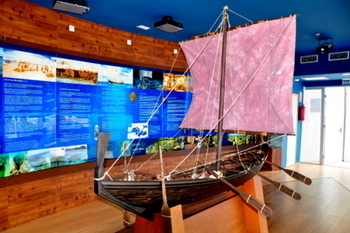
Visitors centre for the 2600-year-old Phoenician boats of Mazarrón I and Mazarrón II Mazarrón is the location of an important marine archaeological site in the Playa de la Isla, one of the beaches on the coastal road leading out from Puerto de Mazarrón to Bolnuevo. The wrecks of two Phoenician boats have been discovered in Mazarrón, dating back to the 6th/7th century BC, one of them (Mazarrón II) in remarkably good condition: these provide..
A 16th century watchtower built to protect Mazarrón against Berber pirates The Torre de los Caballos is part of the defensive system of watchtowers which protected against the constant incursions by Berber pirates from north Africa, who threatened the Murcia coastline from the 16th to the 18th century. The Berbers targeted the area with the aim of taking cattle, goods and hostages, who were either ransomed or sold as slaves in the..
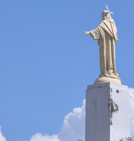
A lovely walk up to the best views in Mazarrón They say that God has all the best views, and that claim can certainly be verified in Mazarrón as the views from the foot of the Sagrado Corazón de Jesús are absolutely stunning. The emblematic figure of Christ is perched right at the top of the Cabezo del Faro, the highest point of the rocky cliffs which envelop Mazarron, close to the lighthouse. The lighthouse was once the..
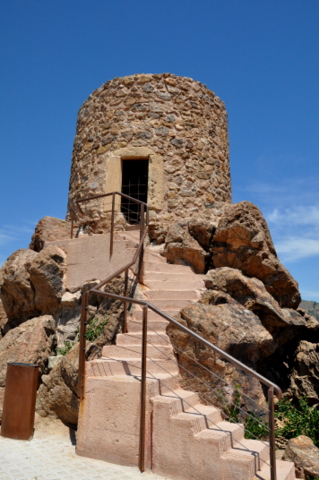
The Torre del Molinete watchtower dates from 1490 and affords great views of the Mazarrón area La Torre del Molinete was built in 1490 by the Catholic Monarchs of Spain to protect the area surrounding Mazarrón, as this was a zone of constant conflict at the time. Mazarrón was rich in mineral deposits, including silver, and had been mined since before 600BC. Indeed, the famous Mazarrón Phoenician boats which were discovered in the bay..
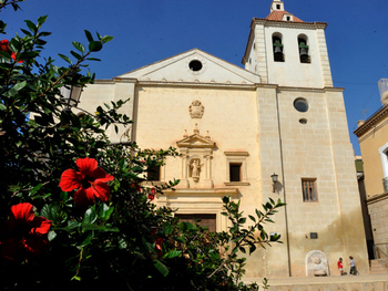
The 16th and 17th century church of San Antonio de Padua in Mazarrón Mazarrón is unusual in that it has two parish churches, a situation which arose due to the concessions granted to two powerful families, the Fajardos (Marqueses de los Vélez) and the Pachecos (Marqueses de Villafranca) each of whom built their own church (click for a brief history of Mazarrón). The Church of San Antonio de Padua is situated next to the modern Town..
Mass is celebrated daily at the Church of San Andrés in Mazarrón This is the church used most extensively for worship today within the town of Mazarrón and offers daily mass for those living in or visiting the town. (Mass is held in Spanish.) Don't be misled by the broken tile plaque outside the door. This church is within the Cartgena Diocese and the parish of San Anton de Padua, and although it is the Iglesia de San Andrés visitors..
The rocky outcrop of Cabezo del Castellar is an important archaeological site set among the most popular beaches of Mazarrón At first sight there is nothing out of the ordinary about this 26-metre-high rocky outcrop to the south-west of Puerto de Mazarrón, joined to the mainland by a thin strip of land which divides the two bays of Playa Grande and Playa de Nares, but in fact it is home to a surprisingly significant archaeological site...
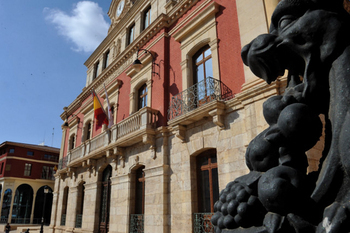
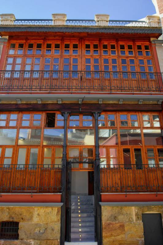
Sala de exposiciones Casas Consistoriales Mazarrón The construction of the building began on July 9 1889 with Francisco de Ródenas as the architect although two years later the project was taken over by the architect Francisco de Paula y Oliver, who was working in Cartagena although originally from Catalunya. This time was the era of greatest productivity in the Mazarrón mines, at a time when the town had 40,000 inhabitants and a wealthy..
Alum was the main source of wealth in Mazarrón in the Late Middle Ages Alum is a chemical compound containing potassium which was much used in the Late Middle Ages to fix colouring in tanning and textiles, and the substance plays an important role in the history of Mazarrón due to its being found naturally in the minerals of the old mines just outside the town. This was a particularly valuable commodity which also had other industrial, domestic..
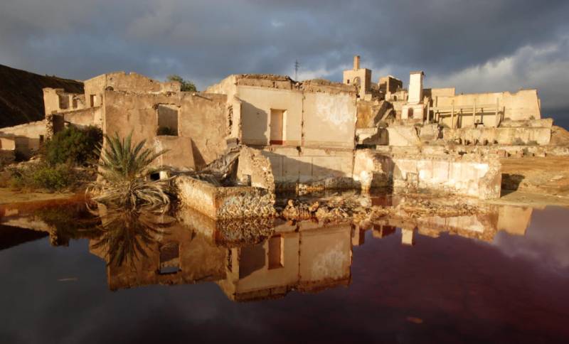
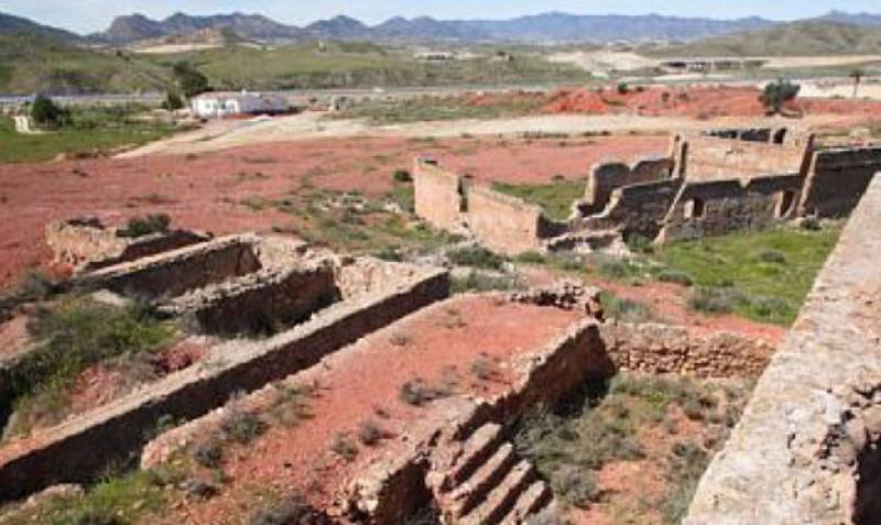
Eerie abandoned buildings stand in a surreal landscape of red and ochre rocks just outside Mazarrón Just to the north of the town of Mazarrón is the eerie landscape of the abandoned mines which were first created by the Romans around 2,000 years ago and which reached the peak of their activity in the 19th and early 20th centuries, leaving behind a series of abandoned structures and buildings and an almost surreal area of brightly coloured rocks..
This late 19th century building was constructed during a period of great prosperity in Mazarrón Work has been completed in the town of Mazarrón to restore and renovate the old Ateneo Cultural, or Casino, which was built in the late 19th century at a time when there was great wealth and prosperity in the area due to the mining activity in the mountains just north of the town centre. Very little concrete evidence exists regarding the origins..
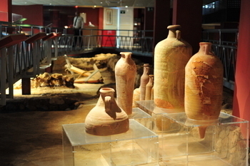
Museo Arqueológico Municipal de Mazarrón, La Factoría Romana de Salazones During the 1st century BC, Roman power was at its height and the Empire required vast quantities of goods from across the Mediterranean for consumption elsewhere. Commerce along the Mediterranean coastline provided a wealth of goods and services, each area contributing its own locally produced specialities. Mazarron had four important products: minerals from its..
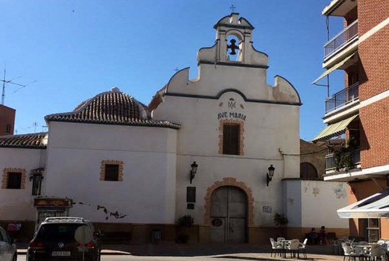
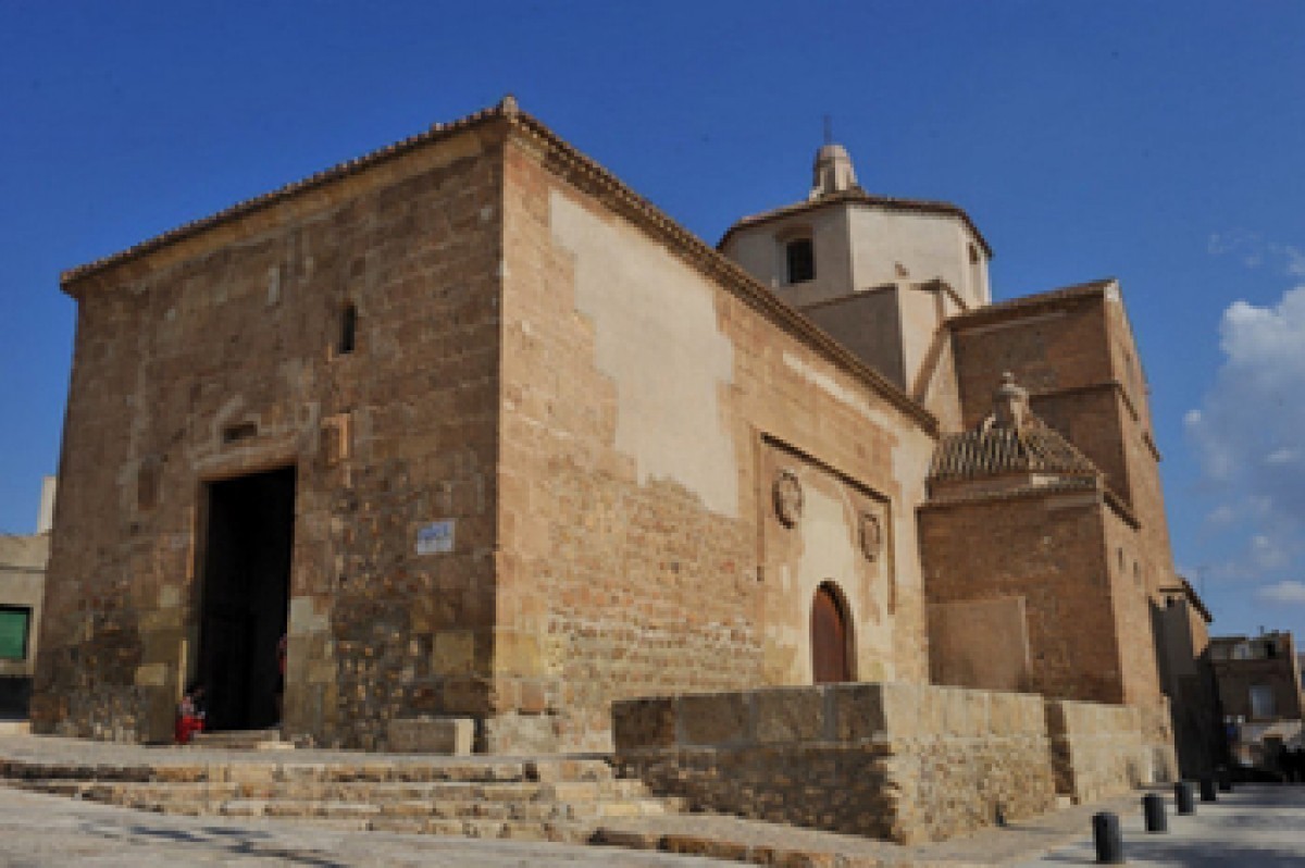
The church of La Purísima in Mazarrón 16th-18th century Iglesia del Convento de la Purísima The Convento de la Purísima is located in the heart of the old town of Mazarrón, overlooking the main market square which formerly housed the Plaza de Abastos or indoor marketplace. It's not clear when the cult of the Virgen de la Concepción began in Mazarrón, the first recorded evidence being a book by Fray Ginés García in 1756..
The remains in El Alamillo and Calle Era bear witness to the Roman past of Mazarrón The Roman Villa at El Alamillo The city of Cartagena was taken by the Romans from the Carthaginians in 209BC and they swiftly set about exploiting the natural resources of the area, establishing a settlement in what is now Mazarrón, which they named "Ficaria". Their interest in the area stemmed from its proximity to Cartagena, which the..
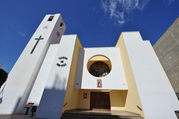
Parroquia de San José in Puerto de Mazarrón This is the main Catholic church in Puerto de Mazarrón, and Mass is held in Spanish throughout the year. Two other churches in Mazarrón itself also offer Mass 12 months a year, the most central being the Iglesia del Convento de la Purísima. Winter Mass times at San José are as follows: Monday: 9.30 Tuesday to Friday: 19.30 Eve of Feast days: 19.00 Sundays and Feast days: 12.30..
Punta de Gavilanes is an important archaeological site and has great views over the Mazarrón coastline Punta de Gavilanes (Puerto de Mazarrón) is located between the beaches of Bahía and La Pava, and was occupied during four distinct periods, starting nearly 4,000 years ago. The area consists of two promontories: the larger and higher of the two is known as the Pico del Águila, while the lesser is the Punta de Los Gavilanes. The archaeological..
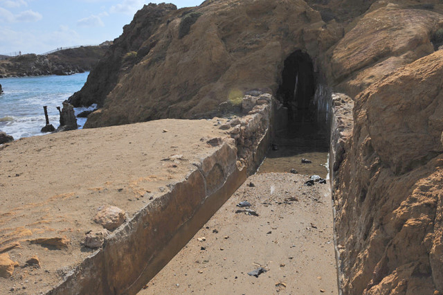
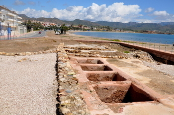
In the past there was an important salt production industry in Mazarrón Salt production was an important industry in Mazarrón for centuries, and although the remains of this activity which exist today date from the 20th century similar infrastructures were certainly in place during the Roman era. Under Roman rule, Mazarrón was a centre of production for garum, a pungent fish sauce, and also other products which required salt...
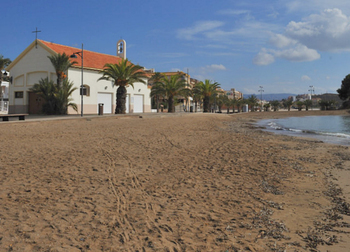
The small church alongside the Playa de la Isla in Puerto de Mazarrón This attractive little church is located alongside the beach of Playa de la Ermita in Puerto de Mazarrón, and Mass is held just once a week, on Saturdays at 18.00 in summer and at 19.00 in winter. The building stands in "DPMT" (Dominio Público Marítimo Terrestre), which technically means that it´s too near to the beach to be legally permitted and should be..
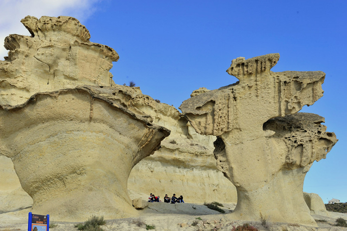
The Bolnuevo erosions are natural sandstone sculptures One of the best known features of Bolnuevo are the erosions, or gredas, of Bolnuevo, sometimes known as the “enchanted landscape”, a curious formation of naturally sculptured rock formations behind the main beach. These limestone shapes have been formed over millions of years by wind erosion, and seem almost like modernist sculptures. The white clay of which they consist is a mixture..
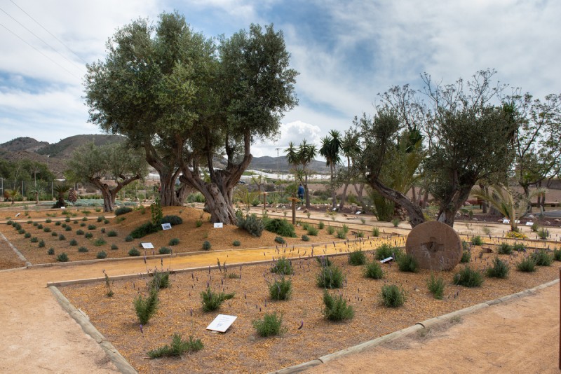
The “Mastia” garden is designed to educate about local eco-systems In April 2018 Mazarrón became the first municipality in the Region of Murcia to open an educational bio-garden for local residents, featuring examples of over 100 plant species which are native to the Mediterranean coastal regions of Spain and others which represent the eco-systems of the African and American continents. The Jardín Etnobotánico “Mastia”..

Saturday and Sunday are market days in Mazarrón and Puerto de Mazarrón Shopping is always enjoyable at one of the many outdoor and indoor markets across the Region of Murcia, which are traditionally the main source of fresh produce for towns and villages. In general prices are competitive in comparison with supermarkets, particularly if vendors are competing for trade! There are lots of very Spanish goodies on offer at these markets..