- Region
- Águilas
- Alhama de Murcia
- Jumilla
- Lorca
- Los Alcázares
- Mazarrón
- San Javier
-
ALL AREAS & TOWNS
- AREAS
- SOUTH WEST
- MAR MENOR
- MURCIA CITY & CENTRAL
- NORTH & NORTH WEST
- TOWNS
- Abanilla
- Abarán
- Aguilas
- Alamillo
- Alcantarilla
- Aledo
- Alhama de Murcia
- Archena
- Balsicas
- Blanca
- Bolnuevo
- Bullas
- Cañadas del Romero
- Cabo de Palos
- Calasparra
- Camping Bolnuevo
- Campo De Ricote
- Camposol
- Canada De La Lena
- Caravaca de la Cruz
- Cartagena
- Cehegin
- Ceuti
- Cieza
- Condado de Alhama
- Corvera
- Costa Cálida
- Cuevas De Almanzora
- Cuevas de Reyllo
- El Carmoli
- El Mojon
- El Molino (Puerto Lumbreras)
- El Pareton / Cantareros
- El Raso
- El Valle Golf Resort
- Fortuna
- Fuente Alamo
- Hacienda del Alamo Golf Resort
- Hacienda Riquelme Golf Resort
- Isla Plana
- Islas Menores & Mar de Cristal
- Jumilla
- La Azohia
- La Charca
- La Manga Club
- La Manga del Mar Menor
- La Pinilla
- La Puebla
- La Torre
- La Torre Golf Resort
- La Unión
- Las Palas
- Las Ramblas
- Las Ramblas Golf
- Las Torres de Cotillas
- Leiva
- Librilla
- Lo Pagan
- Lo Santiago
- Lorca
- Lorquí
- Los Alcázares
- Los Balcones
- Los Belones
- Los Canovas
- Los Nietos
- Los Perez (Tallante)
- Los Urrutias
- Los Ventorrillos
- Mar De Cristal
- Mar Menor
- Mar Menor Golf Resort
- Mazarrón
- Mazarrón Country Club
- Molina de Segura
- Moratalla
- Mula
- Murcia City
- Murcia Property
- Pareton
- Peraleja Golf Resort
- Perin
- Pilar de la Horadada
- Pinar de Campoverde
- Pinoso
- Playa Honda
- Playa Honda / Playa Paraíso
- Pliego
- Portmán
- Pozo Estrecho
- Puerto de Mazarrón
- Puerto Lumbreras
- Puntas De Calnegre
- Region of Murcia
- Ricote
- Roda Golf Resort
- Roldan
- Roldan and Lo Ferro
- San Javier
- San Pedro del Pinatar
- Santiago de la Ribera
- Sierra Espuña
- Sucina
- Tallante
- Terrazas de la Torre Golf Resort
- Torre Pacheco
- Totana
- What's On Weekly Bulletin
- Yecla


- EDITIONS:
 Spanish News Today
 Alicante Today
 Andalucia Today
Begastri Cehegin
Introduction to Begastri, Cehegín
Location of Begastri
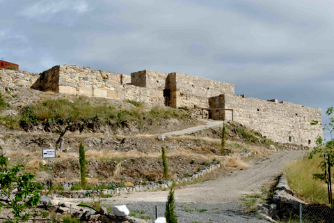 The site is 3km from the centre of Cehegín and is located on the edge of the Vía Verde, popular with both walkers and cyclists alike, a former railway line which linked Murcia and Caravaca and was decommissioned in 1977. For details about visiting the site see below.
The archaeological site of Begastri is located in the modern day municipality of Cehegín, in the North-west of the Region of Murcia.
As archaeologists slowly clear centuries of accumulated earth from this hilltop fortification, it is becoming increasingly clear that this is amongst the most important sites in the region, as although it is believed to have been inhabited continually from the 4th century BC until the 11th century BC, it sheds light on one of the periods about which least is known, the Visigoth occupation of the region, having been an important Iberian, Roman, Byzantine and then Visigoth fortification before being abandoned shortly after the Moorish invasion.
The Begastri site is located on the Cabezo de Roenas, a hilltop 548 metres above sea level, around 150 metres in length, giving a total surface area of 36,800 square metres. The top section which is believed to have held the most important administrative buildings of the town, covers 10,000 square metres.
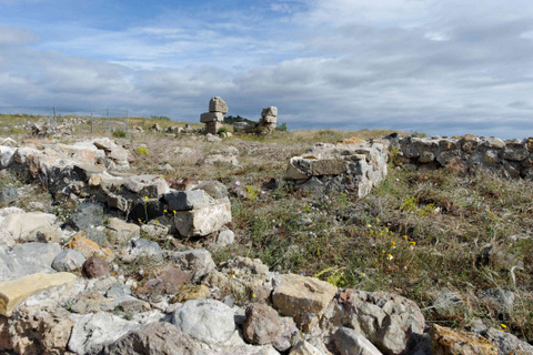 However, the hilltop fortifications are just a fraction of the entire area which would have been occupied, the area excavated to date representing probably only 5% of the total area, with more homes, buildings and administrative buildings spread out at the foot of the Cabezo. Sadly the Cabezo on which this important site is located was badly damaged when construction of the Murcia-Caravaca railway line which is today the Vía Verde cut through its heart, an act which destroyed much of the valuable archaeological site, yet also highlighted its existence, yielding rare and important items such as the Cross of Cehegín, a simple bronze cross which so nearly ended up in a scrapyard.
Subsequent urban development destroyed yet more of the evidence which lay beneath the soil, combined with the brutal aggression of efficient, modern agricultural machinery, which cut deep into the soil below, churning up mosaic floors and remains which lay below the surface, tantalising glimpses of the importance of the site revealed as major sculptural pieces such as the Dama de Cehegín appeared in a hole whilst planting an apricot tree.
But why is this here, and why was it so important?
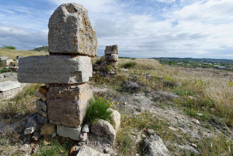 This location would have been selected for two reasons: water resources and strategic advantage.
The height of the Cabezo offered natural safety and a vantage point, giving views across the surrounding country, as well as enabling its occupants to keep watch over two important waterways, the rivers Quípar and Argos, major communications and trade routes.
The site would also have had a natural spring, although today a deep well cut into the cabezo leads down into the watertable below and modern construction has made it impossible to identify the original natural water source.
The area in which the settlement sits is in a flat plain, although surrounded by mountainous peaks and at the time of its first habitation would have included pine forests, as well as open areas of rocky, dense scrub and esparto grass, providing a wealth of natural materials from which the early population could not only build their settlements but exploit in their daily lives.
Wood was used for cooking and building, esparto for weaving and the land cleared for crop cultivation and animal husbandry, the natural waters of the rivers for irrigation, fishing and watering livestock.
The first settlers of Begastri: the Iberians
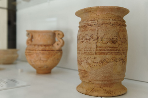 The first inhabitants of the Cabezo de Roenas could well have arrived during the Iron Age, but there is little to indicate any sort of major settlement until the 4th Century BC.
It is difficult to know exactly how extensive this first settlement, built by these settlers, the Iberians, actually was, as the Roman town which was built over the top of the first Iberian settlement buried the remains of the first town, re-cycling the foundations of the dwellings for further construction.This can clearly be seen in some of the walls at the far end of the site, showing the different building materials used, one above the other.
Unlike other important Iberian sites within the region which were abandoned ( The El Cigarralejo in Mula and the Coimbra del Barranco Ancho in Jumilla) this settlement was occupied for hundreds of years after the disappearance of the Iberians.
The Iberians were an essentially agricultural population, although traded with the Phoenicians and Greeks who worked along the Mediterranean coastline, exchanging ceramics, metalwork, hides, luxury goods and even esparto grass. The Iberians also contributed important military warriors to the armies of Greece and Rome during the armed conflicts of the Punic wars, which preceded the Roman invasion of Cartagena in 209BC.
Click Iberians in Begastri for more details about this era of Begastri history.
The Romans in Begastri
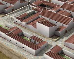 In 209BC the Romans invaded Cartagena and a steady process of Romanization enveloped what is now the Region of Murcia. Agricultural villas were built with the mission of producing food to feed the City of Carthago Nova ( now Cartagena) and the slaves working in the mineral mines in the Sierra Minera ( up to 30,000 at one point) and to produce goods which could be exported, such as olive oil, concentrated fish sauces and wheat.
The Romans brought with them more efficient farming techniques and new processes, new construction techniques and a sophistication hitherto unseen in the Iberian peninsula, the local Iberians slowly embracing their ways and customs. During the era of Roman occupation, Begastri became an important settlement, believed to have contained substantial public buildings and a population of 13,000 people, the equivalent of the modern day population of Cehegín.
Click for full information, Begastri under the Romans.
The Visigoths and Byzantines in Begastri.
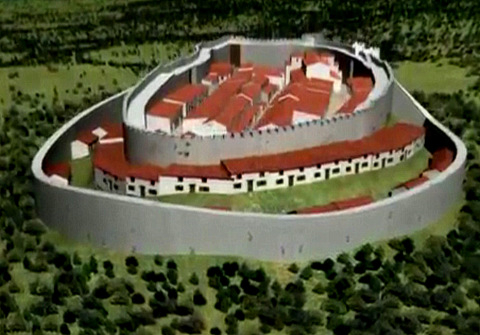 By the end of the 3rd Century AD, the engorged Roman Empire was struggling to control its vast territories, and was divided into two following nearly a century of succession instability. Barbaric Germanic tribes started to spread across Europe, the Goths, once allies of the Romans creating a vast territory which swallowed up Spain, and sacked Rome, Hispania, a Visigoth Kingdom. Fearful of the invading barbarians, the population of Begastri dismantled the imposing public buildings, using the stone to build 5 metre thick defensive walls, and filling the space created with dwellings.
The Visigoths occupied Begastri until the Byzantines( half of the former Roman Empire,) claimed Cartagena as part of their efforts to regain the lost lands of the Roman Empire and Begastri reverted to Byzantine control for a period of around 50 years.
A second defensive wall was constructed to protect the town, which lay on the border between Visigoth and Byzantine lands, but the Byzantines were defeated and pushed out of Spain, and Cartagena, which had been the capital of Byzantine territories, razed to the ground. Begastri reverted to the Visigoths, and became an Episcopal seat, and a Visigoth town of substance.
But power struggles for succession again played a hand and in 711 a fatal miscalculation between warring tribes prompted the Moorish invasion, and the subsequent 500 years of Moorish dominance of the Iberian peninsula.
Click for more information about the Visigoths in Begastri
The Moors in Begastri
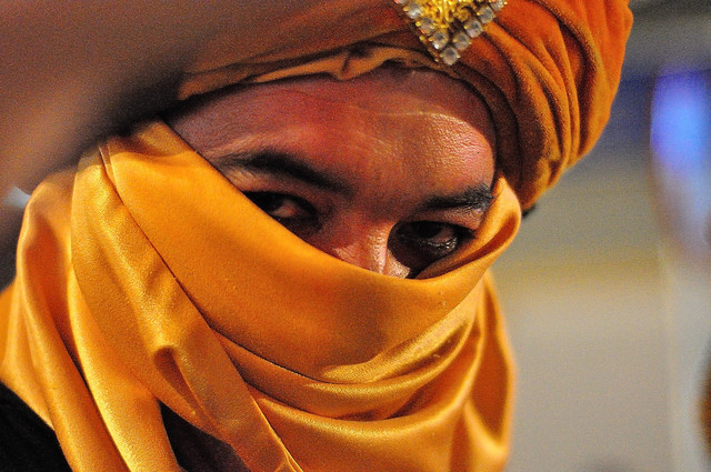 The fall of the Visigoths was prompted by an internal succession conflict, during which a request for support from Moorish troops backfired, when the allies became the invaders and took the Kingdoms of Hispania for themselves. The struggles began in 711 and by 713 the Governor of Aurariola (Orihuela), Duke Teodomiro, realised resistance was futile and sought damage limitation by signing a peace treaty with Abd Al-Aziz, the chief of the Moorish army in the Eastern coastal region.
The terms of this treaty, known as the Pact of Teodomiro, (pact of Tudmir) recognized Islamic sovereignty in Hispania, and established the grounds for peace and religious freedom by establishing a system of tributes payment. By the same treaty Teodomiro was granted political autonomy in his government of the region, which was known as the kingdom of Tudmir, and remained in power throughout his lifetime
There was some Visigoth resistance in the south-east, though, led by Duke Teodomiro, the governor of the province of Aurariola (Orihuela), which included the modern-day provinces of Alicante, Albacete, Murcia and the northern part of Almería. Eventually, in 713, Teodomiro saw that he could no longer repel the Moors’ advance and found himself obliged to sign a peace treaty with Abd Al-Aziz, the chief of the Moorish army in the Eastern coastal region.
The terms of this treaty, known as the Pact of Teodomiro, ( pact of Tudmir) recognized Islamic sovereignty in Hispania, and handed over to the Moors the territories of Aurariola (Orihuela), Leucante/Lucentum (Alicante), Balantala (Villena or Valencia), Mula, Eliocroca (Lorca), Begastri (Cehegín) and Eio (Hellín or Elche), as well as establishing the payment of tributes in return for peace and religious freedom. By the same treaty Teodomiro was granted political autonomy in his government of the region, which was known as the kingdom of Tudmir, and remained in power throughout his lifetime.
Population of the newly conquered territories was a slow process and there are no written records to help historians and investigators work out what happened in towns such as Begastri when the Moorish population first started to arrive, and whether the new arrivals simply built their own accommodation immediately or moved into existing settlements. And there are no records to indicate what happened to the Visigoth population who lived here.
What is known is that Begastri was slowly abandoned, as the Moorish tribe which settled in the area, the Zenehegis (from which Cehegín gained its name) decided to build on the Puntarrón hill, about 3km from Begastri, and although some farmers remained in the urban nucleus of Begastri until the 10th century the old town remained largely uninhabited.
And slowly Begastri crumbled, used as a shelter by shepherds, its stone carted off into the new settlements to be used as building materials, slowly covered by earth and vegetation until it blended into the hillside and was forgotten.
Click here to read about the Moors in Begastri.
Modern Begastri
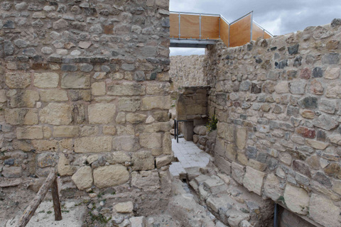 As Cehegín entered the modern age and industrialisation took place, advances in agricultural technology lead to more deep ploughing techniques and increasing numbers of archaeological remains came to light, the first documented being a piece of stone with an inscription which was discovered in 1826.
The subsequent discovery gave the name of the church and the name of the settlement as Begastri, although at the time little real value is put on the finds being made and in the 1920s the Murcia-Caravaca de la Cruz railway line was cut through the side of the Cabezo, destroying much of the former settlement.
In 1980 administrative processes to declare the site of cultural interest were begun and the excavations commenced in earnest, and in 2002 Begastri was declared a zone of archaeological interest, given a BIC protection level.
Practicalities of visiting Begastri
Where is Begastri?
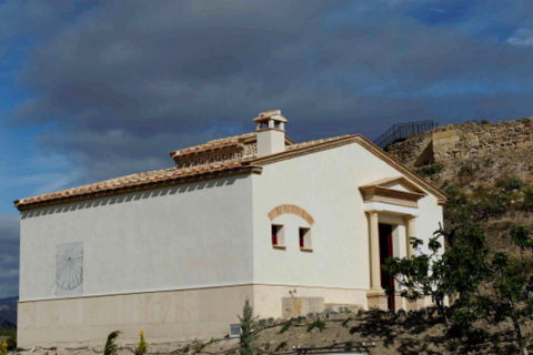 The site is best accessed by leaving the Murcia-Caravaca C415 Autovía at the junction marked Cehegín-Este, Cehegín east. Arriving at the roundabout with a sculpture of the Cross of Cehegín, carry straight on, and you´ll see the Vía Verde on the right. If walking, walk down the Via Verde and Begastri is about half a km down. Otherwise continue down the road and turn right into the orchard area, signposted for Escobar. Further down, there is a right fork for Begastri, turn right just past the house with the elephants (youll understand when you see it!). Although the Via Verde says no cars, there is a car park at the foot of the site by the visitor centre.
The Begastri visitor centre
The visitor centre is open from 10am to 2pm on Saturdays and Sundays.
There are 3 visiting times:
10.10 am Video followed by guided route.
11.15 am
12.30 Midday
The visits are guided, and the tour is in Spanish, although the guide speaks enough English to give basic information and all the display boards have an english translation.
Entry is 2 euros.
Visits can be arranged for groups at other times by calling the tourist office on 968 723 550.
It is also worth visiting the Archaeological Museum in Cehegín, which has a collection of artefacts from the site as well as other items relating to the History of Cehegín.
ALL TEXT AND IMAGES ARE COPYRIGHT OF MURCIA TODAY AND MAY NOT BE REPRODUCED WITHOUT PRIOR AGREEMENT.PLEASE RESPECT THE WORK WHICH HAS GONE INTO PREPARING THIS INFORMATION.
Cartagena
El Carmoli
Islas Menores and Mar de Cristal
La Manga Club
La Manga del Mar Menor
La Puebla
La Torre Golf Resort
La Union
Los Alcazares
Los Belones
Los Nietos
Los Urrutias
Mar Menor Golf Resort
Pilar de la Horadada
Playa Honda / Playa Paraiso
Portman
Roldan and Lo Ferro
San Javier
San Pedro del Pinatar
Santa Rosalia Lake and Life resort
Terrazas de la Torre Golf Resort
Torre Pacheco
Aledo
Alhama de Murcia
Bolnuevo
Camposol
Condado de Alhama
Fuente Alamo
Hacienda del Alamo Golf Resort
Lorca
Mazarron
Puerto de Mazarron
Puerto Lumbreras
Sierra Espuna
Totana
Abaran
Alcantarilla
Archena
Blanca
Corvera
El Valle Golf Resort
Hacienda Riquelme Golf Resort
Lorqui
Molina de Segura
Mosa Trajectum
Murcia City
Peraleja Golf Resort
Ricote
Sucina
Condado de Alhama
El Valle Golf Resort
Hacienda del Alamo Golf Resort
Hacienda Riquelme Golf Resort
Islas Menores and Mar de Cristal
La Manga Club
La Torre Golf Resort
Mar Menor Golf Resort
Mazarron Country Club
Mosa Trajectum
Peraleja Golf Resort
Santa Rosalia Lake and Life resort
Terrazas de la Torre Golf Resort
La Zenia
Lomas de Cabo Roig
CAMPOSOL TODAY Whats OnCartagena SpainCoronavirusCorvera Airport MurciaMurcia Gota Fria 2019Murcia property news generic threadWeekly Bulletin


