Why the floods in Valencia happened and who is responsible
There’s a reason why the flooding was worst in the towns surrounding Valencia city, and the explanation goes back more than half a century...
by John Michael Kirby, Technical Architect and Building Engineer
To the south of the city of Valencia, not incidentally close to the worst affected areas of the floods, is a large lake, to be exact a large salt water lagoon.
Some of you may have seen the before and after pictures of how the lagoon has grown in size to the point that it joined the southern part of the city with the lagoon.
In fact, the only lagoon exists as a direct result of this sporadic flooding and its corresponding silt deposits brought there from the surrounding, normally dry, riverbeds.
The flow of these riverbeds, or ramblas as they are known in Spanish, tends to go from almost zero to extremely high in the intense periods of rainfall.
The floods happened because they have happened on a regular basis over the centuries here.
Historically, meteorologically and geo-morphologically (the lay of the land, Valencia is very flat to the south), we know the flooding was to be expected. So why in that case was there so much damage this time in the areas to the south in comparison to previous flooding?
The last time it flooded this badly, in 1957, people didn’t live in those areas. This is partly due to the fact that people knew this was a floodable area, partly because technology did not allow for large structures to be built on swampy land at that time and partly because the economic model of coastal exploitation for residential and residential touristic purposes was yet to come at that time.
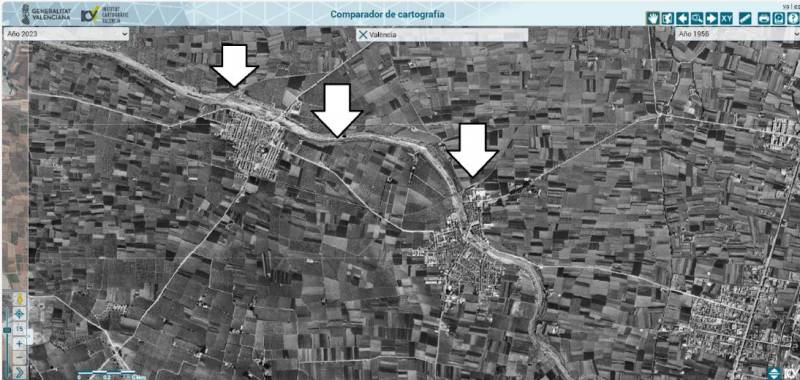
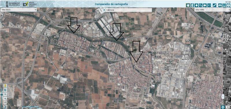
We have orto-photos, aerial photos, of that area dating back to 1956, just before the last big flood, so you can see just how much development has taken place in that area. Take a look at three of the worst affected areas: Picanya, Paiporta and Massanassa.
1956
2023
As you can see, Paiporta didn’t exist on any significant level as a residential area. But since 1957, the urban development was allowed to take place on a known flood plain for decades, with measures only being taken to protect the city of Valencia and not the surrounding areas.
However, that is not the worst of the situation. In 2003, a regional study was undertaken and completed for flood risks and every single area was classified for risk if that risk existed, level 6 being the lowest risk and level 1 the highest, with not only river flooding assessed but, also geomorphologic risk (the way water flows around the topography).
There are publically accessible maps from PATRICOVA, free of charge to find out if a property or area faces a risk and what the risk assessment is via this link. You can see instructions in the video below for how to see if your Valencia home is at risk of flooding:
In conclusion, every house at risk was known to be at risk and houses were still allowed to be built on that land en masse for decades.
And who is to blame for the tragedy? The public administration at a local and regional level at the time of constructing those properties, firstly for giving permission to build them and more importantly – and less forgivably – deciding that the owners of those properties did not need to know that they were at risk.
The PATRICOVA information, although freely and publicly available, is not given to prospective buyers. It’s not required for estate agents to present to potential buyers, it’s not read out by notaries or banks to the buyers at the time of purchase. It’s kept on a hard drive, in a cloud somewhere, and tragically, unless the law changes, that’s where it will continue to stay.
John Kirby is a Technical Architect and Building Engineer (UPV), having won the award for outstanding academic achievement. He is the first foreigner to win that award and the only foreigner to ever be Municipal Technical Architect in Spain and a Judicial Property expert witness in Spain. He is Commisioner for Expatriates of the Valencian government and Ambassador for Spain and Gibraltar for Chartered Association of Building Engineers (UK).
To be listed on the CAMPOSOL TODAY MAP please call +34 .
To be listed on the CONDADO TODAY MAP please call +34 .
Guidelines for submitting articles to Camposol Today
Hello, and thank you for choosing CamposolToday.com to publicise your organisation’s info or event.
Camposol Today is a website set up by Murcia Today specifically for residents of the urbanisation in Southwest Murcia, providing news and information on what’s happening in the local area, which is the largest English-speaking expat area in the Region of Murcia.
When submitting text to be included on Camposol Today, please abide by the following guidelines so we can upload your article as swiftly as possible:
Send an email to editor@camposoltoday.com or contact@murciatoday.com
Attach the information in a Word Document or Google Doc
Include all relevant points, including:
Who is the organisation running the event?
Where is it happening?
When?
How much does it cost?
Is it necessary to book beforehand, or can people just show up on the day?
…but try not to exceed 300 words
Also attach a photo to illustrate your article, no more than 100kb