- Region
- Águilas
- Alhama de Murcia
- Jumilla
- Lorca
- Los Alcázares
- Mazarrón
- San Javier
-
ALL AREAS & TOWNS
- AREAS
- SOUTH WEST
- MAR MENOR
- MURCIA CITY & CENTRAL
- NORTH & NORTH WEST
- TOWNS
- Abanilla
- Abarán
- Aguilas
- Alamillo
- Alcantarilla
- Aledo
- Alhama de Murcia
- Archena
- Balsicas
- Blanca
- Bolnuevo
- Bullas
- Cañadas del Romero
- Cabo de Palos
- Calasparra
- Camping Bolnuevo
- Campo De Ricote
- Camposol
- Canada De La Lena
- Caravaca de la Cruz
- Cartagena
- Cehegin
- Ceuti
- Cieza
- Condado de Alhama
- Corvera
- Costa Cálida
- Cuevas De Almanzora
- Cuevas de Reyllo
- El Carmoli
- El Mojon
- El Molino (Puerto Lumbreras)
- El Pareton / Cantareros
- El Raso
- El Valle Golf Resort
- Fortuna
- Fuente Alamo
- Hacienda del Alamo Golf Resort
- Hacienda Riquelme Golf Resort
- Isla Plana
- Islas Menores & Mar de Cristal
- Jumilla
- La Azohia
- La Charca
- La Manga Club
- La Manga del Mar Menor
- La Pinilla
- La Puebla
- La Torre
- La Torre Golf Resort
- La Unión
- Las Palas
- Las Ramblas
- Las Ramblas Golf
- Las Torres de Cotillas
- Leiva
- Librilla
- Lo Pagan
- Lo Santiago
- Lorca
- Lorquí
- Los Alcázares
- Los Balcones
- Los Belones
- Los Canovas
- Los Nietos
- Los Perez (Tallante)
- Los Urrutias
- Los Ventorrillos
- Mar De Cristal
- Mar Menor
- Mar Menor Golf Resort
- Mazarrón
- Mazarrón Country Club
- Molina de Segura
- Moratalla
- Mula
- Murcia City
- Murcia Property
- Pareton
- Peraleja Golf Resort
- Perin
- Pilar de la Horadada
- Pinar de Campoverde
- Pinoso
- Playa Honda
- Playa Honda / Playa Paraíso
- Pliego
- Portmán
- Pozo Estrecho
- Puerto de Mazarrón
- Puerto Lumbreras
- Puntas De Calnegre
- Region of Murcia
- Ricote
- Roda Golf Resort
- Roldan
- Roldan and Lo Ferro
- San Javier
- San Pedro del Pinatar
- Santiago de la Ribera
- Sierra Espuña
- Sucina
- Tallante
- Terrazas de la Torre Golf Resort
- Torre Pacheco
- Totana
- What's On Weekly Bulletin
- Yecla


- EDITIONS:
 Spanish News Today
 Alicante Today
 Andalucia Today
ARCHIVED - What is the “Rambla” that runs through Camposol and why is it so important?
An explanation of the confusing situation and crucial impact caused by a dry riverbed
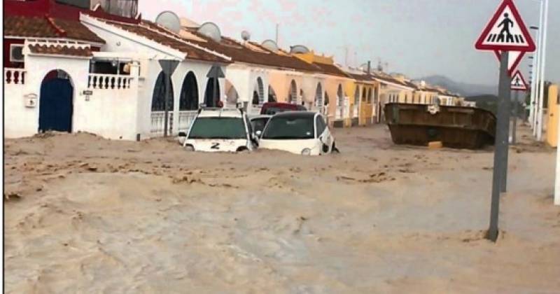 The Rambla in question is the Rambla de los Aznares, which is a dry river bed that has existed possibly for many thousands – if not millions – of years and runs between the El Saladillo and Gañuelas areas of the Mazarrón municipality.
Ramblas are a natural phenomenon forged by water over many years after short periods of intense rainfall. This part of Spain is classed as arid or semi-arid, and although rain does not fall regularly, when it does it can be torrential, especially if another phenomenon occurs: the Gota Fría (Cold Drop).
A Gota Fría is a weather event precipitated by hot, humid and water-laden air in the south (normally when the Mediterranean is warm) colliding with cold air usually from the north or at high altitude, causing huge amounts of water to be dumped on the area below, which explains why “Gota Fría” are very localised events.
When the deluge of water falls inland – particularly in mountainous areas – the water will find its own route by following gravity and over the millennia these routes are shaped. Some can have small amounts of water travelling though permanently, while others may be completely dry for many years. But when the rains fall in the right (or wrong!) location, the ramblas can turn into raging torrents even though the rain may not be falling in that location.
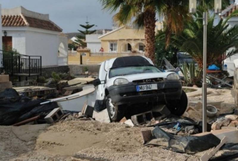 The potential danger of Ramblas is well known in Spain and because of this all main rambla routes are the domain of the Spanish government, including the land extending 110 metres either side of the rambla course to allow for potential flooding. This is called the ‘delimitation zone’ and should not be built on without prior planning consideration to deal with possible water flow and the consent of the appropriate government department. In Camposol’s case, this is the CHS Confederación Hidrográfica del Segura – the water infrastructures authority for the Segura river basin.
How does this affect Camposol?
In the early 2000s, after Camposol constructor Justo y Manoli SL (Grupo MASA) had made inroads into the building of sectors A & B of the development, they turned their attention to sectors C & D, allowing for the obvious existing Moreras tributary rambla which permanently has flowing water and separates B and C. Allowances were made for this rambla including building at bridge to facilitate access.
What was not so obvious was a second dry rambla (the Aznares) that made its course through what is now sector D following a north-to-south path roughly in line and east of what is now Calle Piteras. It seems that at the time of planning there was some confusion over whether Grupo MASA enquired about possible rambla routes to the CHS, but what is known is that MASA started to build dwellings on the course of the river bed and protected area (as shown in the shaded area on the plan below).
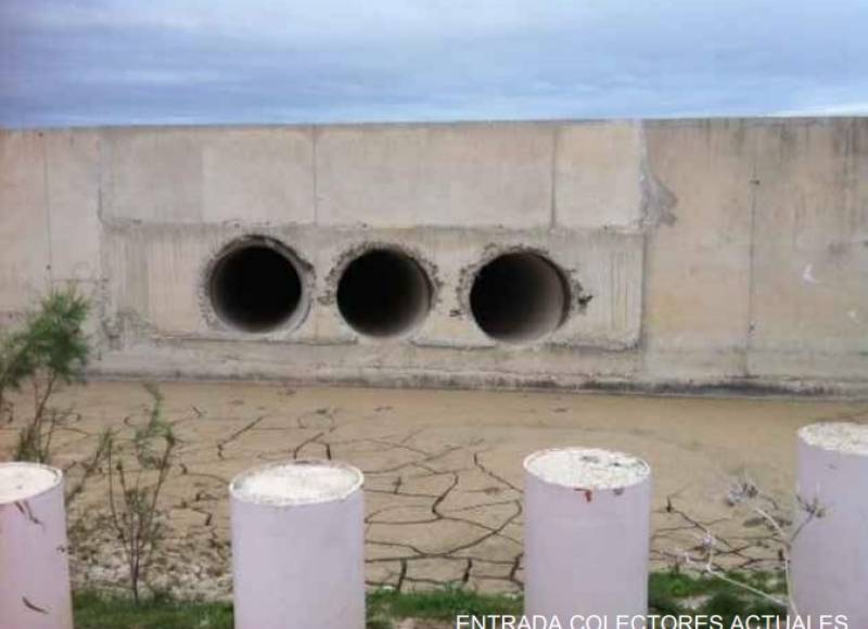
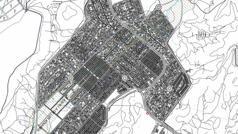 Although it became clear that a rambla did exist after building had started, Grupo MASA refused to stop building – despite court orders obtained by Mazarrón Council to do so – and instead installed 3 large drainage tubes which had to weave through the 600-plus buildings already started. These tubes proved wholly inadequate, as became apparent during the Gota Fría and resulting flooding in September 2014.
 Since it was discovered that properties and infrastructure had been built on the Aznares rambla, there has been much finger-pointing and blame apportioned between the authorities, Mazarrón Council and the CHS and the constructor MASA. This has led not only to the flooding of 2014, but also the refusal of the CHS to approve the plans of Camposol sectors B, C and D.
Attempts have been made to resolve the issue, including a report and recommendations by the Regional Assembly and proposed re-channelling of the rambla. The CHS also levied fines in 2017 on Mazarrón Council and MASA, possibly in an attempt to deflect blame and shield itself from liability, although these fines were overturned on appeal by Mazarrón Council in July of this year and costs awarded against the CHS.
The latest attempt to find a permanent solution to the costly and complicated affair is meetings of a “Roundtable” consisting of the relevant authorities CHS, Mazarrón Council and the Murcia Regional Government. These roundtable meetings, which also include the Camposol Residents Association, are aimed at agreeing and approving a new route for the rambla so the risk of flooding is eliminated and the plans can be finally approved.
There is optimism that a solution will be agreed but it may take some time.
For more local news, events and other information go to the home page of Camposol Today
Cartagena
El Carmoli
Islas Menores and Mar de Cristal
La Manga Club
La Manga del Mar Menor
La Puebla
La Torre Golf Resort
La Union
Los Alcazares
Los Belones
Los Nietos
Los Urrutias
Mar Menor Golf Resort
Pilar de la Horadada
Playa Honda / Playa Paraiso
Portman
Roldan and Lo Ferro
San Javier
San Pedro del Pinatar
Santa Rosalia Lake and Life resort
Terrazas de la Torre Golf Resort
Torre Pacheco
Aledo
Alhama de Murcia
Bolnuevo
Camposol
Condado de Alhama
Fuente Alamo
Hacienda del Alamo Golf Resort
Lorca
Mazarron
Puerto de Mazarron
Puerto Lumbreras
Sierra Espuna
Totana
Abaran
Alcantarilla
Archena
Blanca
Corvera
El Valle Golf Resort
Hacienda Riquelme Golf Resort
Lorqui
Molina de Segura
Mosa Trajectum
Murcia City
Peraleja Golf Resort
Ricote
Sucina
Condado de Alhama
El Valle Golf Resort
Hacienda del Alamo Golf Resort
Hacienda Riquelme Golf Resort
Islas Menores and Mar de Cristal
La Manga Club
La Torre Golf Resort
Mar Menor Golf Resort
Mazarron Country Club
Mosa Trajectum
Peraleja Golf Resort
Santa Rosalia Lake and Life resort
Terrazas de la Torre Golf Resort
La Zenia
Lomas de Cabo Roig
CAMPOSOL TODAY Whats OnCartagena SpainCoronavirusCorvera Airport MurciaMurcia Gota Fria 2019Murcia property news generic threadWeekly Bulletin


