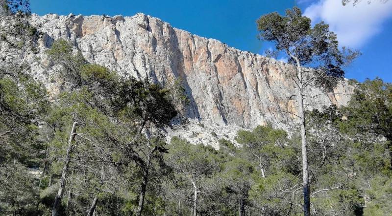
- Region
- Águilas
- Alhama de Murcia
- Jumilla
- Lorca
- Los Alcázares
- Mazarrón
- San Javier
-
ALL AREAS & TOWNS
- AREAS
- SOUTH WEST
- MAR MENOR
- MURCIA CITY & CENTRAL
- NORTH & NORTH WEST
- TOWNS
- Abanilla
- Abarán
- Aguilas
- Alamillo
- Alcantarilla
- Aledo
- Alhama de Murcia
- Archena
- Balsicas
- Blanca
- Bolnuevo
- Bullas
- Cañadas del Romero
- Cabo de Palos
- Calasparra
- Camping Bolnuevo
- Campo De Ricote
- Camposol
- Canada De La Lena
- Caravaca de la Cruz
- Cartagena
- Cehegin
- Ceuti
- Cieza
- Condado de Alhama
- Corvera
- Costa Cálida
- Cuevas De Almanzora
- Cuevas de Reyllo
- El Carmoli
- El Mojon
- El Molino (Puerto Lumbreras)
- El Pareton / Cantareros
- El Raso
- El Valle Golf Resort
- Fortuna
- Fuente Alamo
- Hacienda del Alamo Golf Resort
- Hacienda Riquelme Golf Resort
- Isla Plana
- Islas Menores & Mar de Cristal
- Jumilla
- La Azohia
- La Charca
- La Manga Club
- La Manga del Mar Menor
- La Pinilla
- La Puebla
- La Torre
- La Torre Golf Resort
- La Unión
- Las Palas
- Las Ramblas
- Las Ramblas Golf
- Las Torres de Cotillas
- Leiva
- Librilla
- Lo Pagan
- Lo Santiago
- Lorca
- Lorquí
- Los Alcázares
- Los Balcones
- Los Belones
- Los Canovas
- Los Nietos
- Los Perez (Tallante)
- Los Urrutias
- Los Ventorrillos
- Mar De Cristal
- Mar Menor
- Mar Menor Golf Resort
- Mazarrón
- Mazarrón Country Club
- Molina de Segura
- Moratalla
- Mula
- Murcia City
- Murcia Property
- Pareton
- Peraleja Golf Resort
- Perin
- Pilar de la Horadada
- Pinar de Campoverde
- Pinoso
- Playa Honda
- Playa Honda / Playa Paraíso
- Pliego
- Portmán
- Pozo Estrecho
- Puerto de Mazarrón
- Puerto Lumbreras
- Puntas De Calnegre
- Region of Murcia
- Ricote
- Roda
- Roldan
- Roldan and Lo Ferro
- San Javier
- San Pedro del Pinatar
- Santiago de la Ribera
- Sierra Espuña
- Sucina
- Tallante
- Terrazas de la Torre Golf Resort
- Torre Pacheco
- Totana
- What's On Weekly Bulletin
- Yecla
Sierra de las Herrerías, Leiva ,Mazarrón.
Sierra de las Herrerías, a zone for walking, cycling and pic-nics
The Sierra de las Herrerías is a little known oasis within the municipality of Mazarrón, which offers a number of interesting routes for both cyclists and walkers, as well as being an attractive picnic spot with views out across the Gulf of Mazarrón and surrounding countryside.
The Sierra de las Herrerías is accessed from the D-4, which runs between Leiva and La Atalaya. Once having driven through Leiva, you´ll see a signpost on the left hand side, leading up through the countryside towards the high bank of mountainous Sierras which hold the Roman mines of Coto Fortuna,( see more info below) the mines having been the scene of intense mining activity during several episodes of Mazarron´s history.
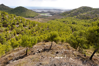
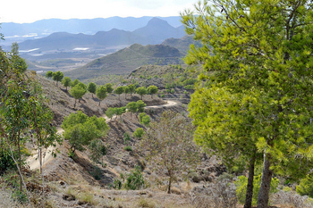
The road winds up, past the abandoned mineworkings of the Mine of San Juan, la mina de san Juan, and up into the Sierra.
As the road climbs past the mineworkings, the landscape becomes one of pine-forests, these being relatively young forests, representative of what would once have covered most of the Region of Murcia over 2000 years ago before intense activity by the Romans began the slow process of deforestation and settlement.
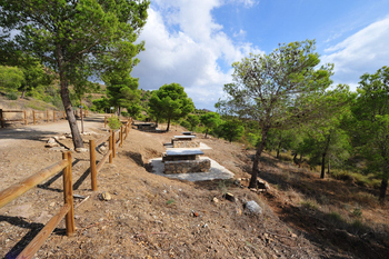
At the top of the Sierra is a newly conditioned picnic area and rest spot, with tables and stone chairs, as well as information boards giving details about some of the wildlife species which abound in the Sierra.
On all sides are roads and walks heading off into the Sierras, with views of the Rambla de las Moreras and the Sierra del Algarrobo to the West. The Sierra del Águila lies to the North, Amenara, la Cresta del Gallo and Lomo de Bas to the East. Las Moreras and the Mediterranean to the South.
On the slopes above is a vigilance station and monitoring point, and all around, silence and the sweet odour of pine.
It´s an astonishing oasis in an area little visited and little known, but well worth visiting if you enjoy walking, cycling or just pick-nicking away from the beaches of Mazarrón.
Click for map, Leiva, Mazarrón. ( pull back and the Sierra clearly shows as a dark green patch)
More basic info about the mines of San Juan and the Coto Fortuna
Extract from the History of Leiva
The Roman Mines
There were most certainly Argaric and Iberian settlements ( dating back to 1800BC onwards) in the countryside of Leiva, especially Coto Fortuna, but any remains of these settlements have been overrun by the abundance of Roman remains in the area.
These are especially related to the intense mining activity which the Romans carried out in the municipality of Mazarrón, and the flat countryside in the plain is still full of old mine shafts and tunnels, while the surface is home to many ceramic and material items from the same historical period.
The resurgence of mining in Mazarrón and other parts of Murcia, as well as in the rest of Spain, at the end of the 19th century, saw civil mining engineers beginning to take an interest in the archaeological evidence which their excavations often uncovered. In 1875, the engineer Alfred Leger produced the first study of the public administration of mines in Ancient Rome, and some of the archaeological findings were included in reports and diaries, a valuable record of many locations which were destroyed during the intensive mining which took place in the Mazarrón area during the 19th and 20th centuries.
Readers with an interest in history may like to read the story behind the Roman invasion of Cartagena which took place in 209BC, a story told in detail in the Cartagena section, ( Click Cartagena history) which effectively saw the end of the Carthaginian domination of this area and the emergence of the Romans, taking full advantage of all the raw materials Spain had to offer.
What is now the Region of Murcia held rich natural resources; salt, esparto grass, fish which was used to make pungent fish sauces, lead, silver and alum.
Murcia was particularly rich in minerals, and the activity was carefully managed and administered.
Regional governors appointed by Rome, were in charge of administering the mines, before the management of mines was handed over to specialized administrators or companies in 180 BC.
Under the Julio-Claudian dynasty, in 68 AD, mines were rented out to individuals under the control of the state, and were sometimes exploited purely for the benefit of the army.
During the reign of Augustus, in 27 BC, the Roman Senate was responsible for the administration of mines, and a manager (or "procurator metallorum") was named in each mine.
The archaeological museum of Cartagena bears ingots recovered from sunken ships bearing the names of the companies who mined and cast them, and similar ingots have been recovered in the Leiva area, so a surprising amount of detail has been gleaned about these mining operations, with extensive field studies also carried out in the tunnels and galleries of Coto Fortuna.
More than a dozen areas have been analysed, and a wealth of material and structures has been found. Among the pieces recovered are column bases, inscription plates, ceramics, metal wedges (a typical tool used at the time), dividing walls from old rooms and even, according to a 19th century inventory, a metal ring containing the remains of a human tibia: this has been taken to indicate the use of slaves in this type of mine.
( In the nearby La Unión and Cartagena mines of the Sierra Minera, over 35,000 slaves are documented as working in the Roman mines.)
The archaeological digs have uncovered galleries, sink shafts, wall support systems, washing areas, tools, sandals and even hats made from esparto grass. The extraction systems seem to have been designed not only to take out the minerals found, but also the water which was encountered when boring into the earth. Among the devices used to dig ever deeper were stepped water wheels, Archimedes screws, and Ctesibius pumps. This technology enabled the Romans to dig far below the surface, despite the underground water deposits which are so abundant in the plains around Mazarrón.
Following the departure of the Romans, the area was occupied by the Moors from Africa until the 13th century, although very little interest was shown in the mines, activity limited to farming. There are no noticeable remains of arab occupation during this period, and the Moors remained until the Christian Reconquista in the middle of the 13th century.
After the Reconquista the population of Mazarrón dropped sharply, and although the countryside must have been dotted with farmhouses and smallholdings from the end of the 13th century onwards, most of the remains found are from watchtowers and small fortresses.
When Granada was taken by the Catholic Monarchs in 1492, ending the Moorish occupation of the south of Spain, there was a re-structuring of Spain, and the arrival of peace and the administrative reforms favoured the reactivation of the industry lost in Mazarrón. The mines in the foothills were re-opened in search of alum, which was now required for glass-making and pharmacology as well as for tanneries.
In the second half of the 15th century the management of the mines was handed to the Fajardo and Pacheco families, who either managed the mines directly or employed others to do so. It is quite possible, given the ties between the lords of Leiva and Mazarrón (which is shown by the inscriptions on some of the houses in the town), that the village could have grown around a house or plot of land belonging to the Leiva family. However there is no documented evidence to support this theory, and little to prove the relationship with the alum mines in Coto Fortuna at the time.
On 1st August 1572 Mazarrón was granted a fundamental privilege, being declared independent and setting up its own Town Hall. The municipality enjoyed its independence from the administration of overlords and military orders, despite suffering from the coastal raids of the Berber pirates throughout the 16th century. These raids and a crisis in the alum industry slowed economic development down in the area, and most of the efforts of the population were devoted to ensuring their safety and survival in the face of the pirate attacks, leading to the countryside and other sources of economic production being rather neglected, and extremely depopulated.
Like other nearby towns in Mazarrón, Leiva grew significantly in the second half of the 19th century in terms of both population and the economy. Mining activity prospered between 1840 and 1918, and this temporarily changed the face of the town. The First World War, in which Spain played no active part, was a great opportunity for the mining industry to increase its exports to the rest of Europe, where metal was needed to produce weapons.
By the end of the 19th century mining in Coto Fortuna was in the hands of the Sociedad Fortuna, based in Bilbao, which invested the handsome sum of five million pesetas in its operations here. Among the numerous mines opened the largest and best known was the San Juan mine, which provided work for many of the locals. The population was swollen by immigrants seeking work, and some of the cave-houses in which they lived can still be seen today: these are very simple dwellings, typical of the temporary workers homes of the age.
Apart from mining, though, there was also increased agricultural activity in the wheat and barley fields of Leiva. Evidence of this can still be seen in the windmills which are dotted along the roadsides, including the Molino de Leiva and the Molino del Rojo Fuentes. When mining activity declined, fruit growing replaced it, although unfortunately the salinity of the water drawn from the local wells meant that it didnt prosper initially.
One by one the mines continued to close, and the last one in Mazarrón ceased to be active in 1967. From then on it became necessary to increase productivity on the land, and the arrival of water from the Tajo-Segura canal in the 1980s made it possible to develop and implement advanced drip-irrigation techniques. From that point on the traditional pomegranates and almonds have been supplemented by melons, water-melons and tomatoes.
Cartagena
El Carmoli
Islas Menores and Mar de Cristal
La Manga Club
La Manga del Mar Menor
La Puebla
La Torre Golf Resort
La Union
Terrazas de la Torre Golf Resort
Los Alcazares
Los Belones
Los Nietos
Los Urrutias
Mar Menor Golf Resort
Pilar de la Horadada
Playa Honda / Playa Paraiso
Portman
Roldan and Lo Ferro
San Javier
San Pedro del Pinatar
Torre Pacheco
Alhama de Murcia
Aguilas
Bolnuevo
Condado de Alhama
Fuente Alamo
Hacienda del Alamo Golf Resort
Lorca
Mazarron
Puerto de Mazarron
Puerto Lumbreras
Sierra Espuna
Totana
Abanilla
Alcantarilla
Archena
Blanca
Corvera
El Valle Golf Resort
Hacienda Riquelme Golf Resort
Lorqui
Molina de Segura
Murcia City
Peraleja Golf Resort
Ricote
Sucina
Condado de Alhama
El Valle Golf Resort
Hacienda del Alamo Golf Resort
Hacienda Riquelme Golf Resort
Islas Menores and Mar de Cristal
La Manga Club
La Torre Golf Resort
Terrazas de la Torre Golf Resort
Mar Menor Golf Resort
Mazarron Country Club
Peraleja Golf Resort

AFS WindfoilsCamposol floods Gota friaCartagena SpainCoronavirusCorvera Airport MurciaCosta Calida tourist infoMedical information MurciaMurcia Gota Fria 2019Murcia propertyParamount Theme Park MurciaWeekly Bulletin